The St. Stepanos Monastery (Armenian: Maghardavank) is an Armenian monastery about 15 km northwest of Jolfa, East Azarbaijan Province, northwestern Iran. It is situated in a deep canyon along the Arax river on the Iranian side of the border between Nakhchivan Autonomous Republic and Iran. Since 2008 it is on UNESCO’s World Heritage List together with the St. Thaddeus Monastery and the Chapel of Dzordzor.
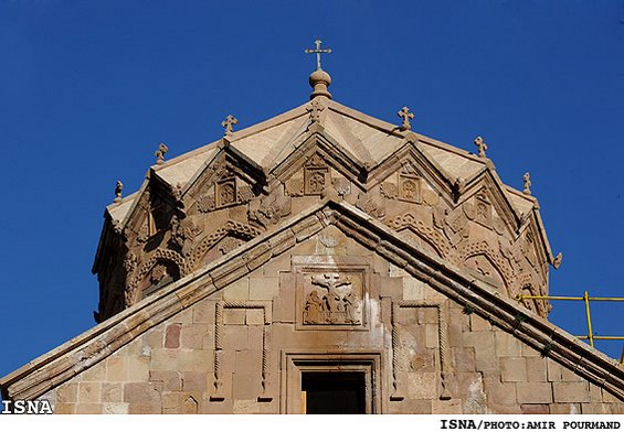
The general structure mostly resembles Armenian and Georgian architecture and the inside of the building is adorned with beautiful paintings by Honatanian, a renowned Armenian artist. Hayk Ajimian, an Armenian scholar and historian, recorded that the church was originally built in the ninth century AD, but repeated earthquakes in Azarbaijan completely eroded the previous structure. The church was rebuilt during the rule of Shah Abbas the Second.
History
The first monastery was built in the seventh century (AD 649) and completed in the tenth century. However, St Bartholomew first founded a church on the site around AD 62 but it was partly destroyed during the wars between the Seljuks and the Byzantine Empire in the eleventh and twelfth centuries.
Following the conquest of the region by the Mongols of Hulagu, grandson of Genghis Khan, in the middle of the thirteenth century, Christians benefited from the favorable Ilkhanid dynasty, and a peace agreement is signed between the Armenian Church and the Ilkhans. The monastery was restored in the second half of the thirteenth century.
The monastery was completely rebuilt in 1330 under the leadership of Zachariah. St. Stepanos Monastery found the height of its cultural and intellectual influence in the fourteenth and fifteenth centuries. The monastery produced paintings and illuminated manuscripts, in areas as diverse as religion, history and philosophy.
In the early fifteenth century, the new Safavid dynasty protected the Armenians but the region is at the center of the rivalry between the Safavids and the Ottomans, who invaded Western Armenia in 1513. St. Stepanos in the sixteenth century observed a gradual decline until Shah Abbas I decided to evacuate the region from its inhabitants in 1604. The monastery then was abandoned. From 1650, the Safavids, however, decided to occupy the region again, and the damaged and abandoned St. Stepanos monastery was restored in the middle of the century.
At the beginning of the eighteenth century, the area became a challenge for the conquest of the Russian Empire. Yerevan was conquered by the Russians in 1827. The border between Persia and Russia was established on the Araxes by the Treaty of Turkmenchay. Consequently part of the population was displaced by force to Russian Armenia. The Qajar rulers continued to protect the Armenians. They encouraged the rebuilding of St. Stepanos Monastery between 1819 and 1825.
The monastery has undergone several restorations recently twentieth and twenty-first centuries, especially since 1974.
On UNESCO World Heritage List
The Armenian monasteries in Northwestern Iran have borne continuous testimony, since the origins of Christianity and certainly since the 7th century, to Armenian culture in its relations and contact with the Persian and later the Iranian civilizations. They bear testimony to a very large and refined panorama of architectural and decorative content associated with Armenian culture, in interaction with other regional cultures: Byzantine, Orthodox, Assyrian, Persian and Muslim. The monasteries have survived some 2,000 years of destruction, both of human origin and as a result of natural disasters. They have been rebuilt several times in a spirit in keeping with Armenian cultural traditions.
Further information: Iran Chamber Society | Church of Saint Stephanos
Sources: Wikipedia | Saint Stepanos Monastery, Iran Chamber Society | Historical Churches in Iran, Tishineh | St. Stepanos Monastery, Wikimedia Commons | Saint Stepanos Monastery, UNESCO World Heritage List | Armenian Monastic Ensembles of Iran, IRNA | Photos 1, IRNA | Photos 2


")
")
")
")
")
")
")
")
")
")
")
")
")
")
")
")